November 11, 2014
The answer to this question is surprisingly large and ill-defined, as a casual examination of metadata records from Australian researchers suggests a surprising diversity: such as latitude, lat, L1, L2.
While this is perhaps amusing to humans who understand the context in which data are presented, computers are not so capable. For example, when the Marine Biodiversity Hub’s marine blueprint team (Theme 1) searches for all national data relevant to monitoring marine ecosystem health using Key Ecological Features (KEFs), we cannot jointly access even the data from NERP researchers. This is because there is no common vocabulary for database field names.
Hub researchers have been working consistently since the days of CERF to improve data delivery to the Department of the Environment: one approach to increasing the Hub’s influence on departmental decision making. We have been working with the Integrated Marine Observing System (IMOS), the Australian Ocean Data Network and the Atlas of Living Australia (FishMap) to provide timely, publically-accessible, long-term archiving of our data and metadata. As a result, Department officers will have improved access to data such as the recorded fish species likely to occur in a particular marine reserve. Global searches generally remain a challenge, however, due to the different names and formats Australian research agencies and institutions have for common variables such as latitude, longitude and depth. This needs to change.
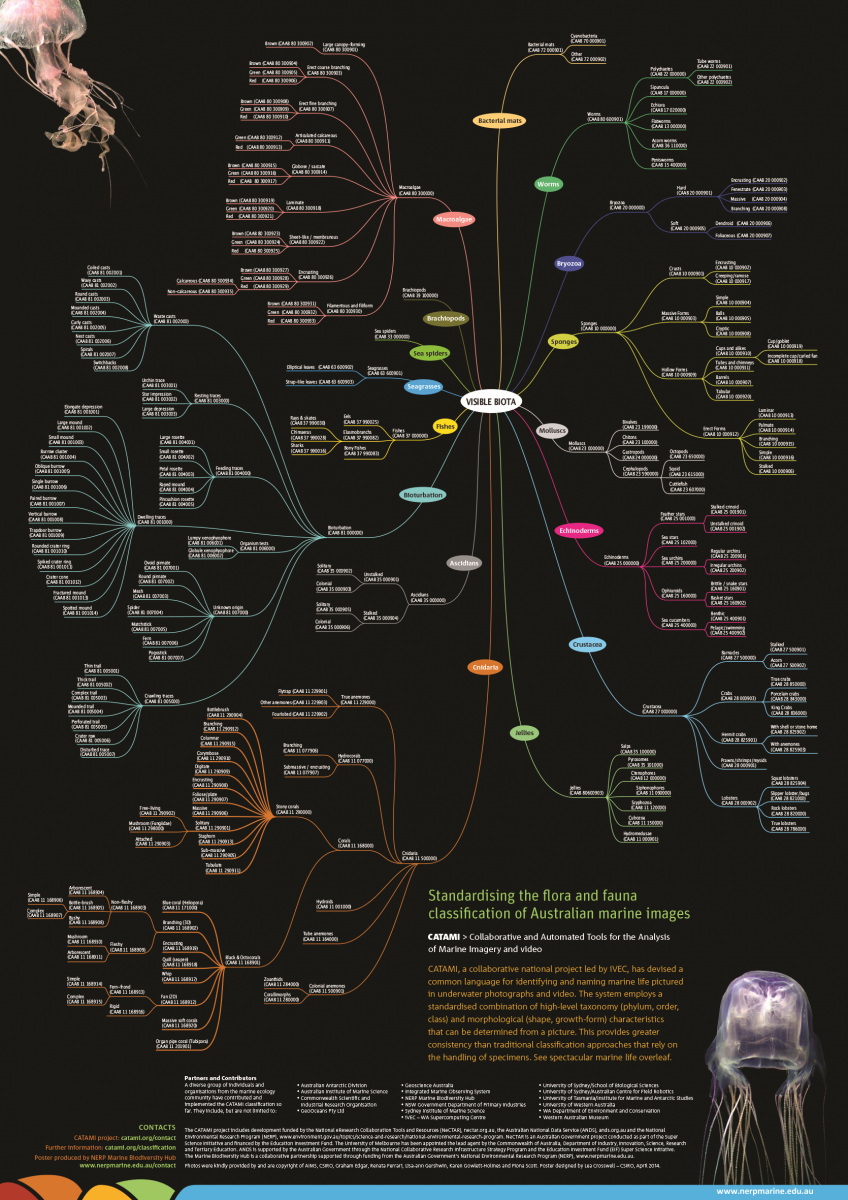
While a common vocabulary will streamline access to national or global data, the data-collection process is also important. To that end, Hub researchers have worked with the Collaborative and Automated Tools for the Analysis of Marine Imagery and video (CATAMI) on a common approach to analysing and classifying marine flora and fauna. Companies consulting to the oil and gas industries have agreed to adopt the CATAMI standard, thereby expanding the information base for planning decisions, ecosystem assessments and State of the Environment reporting. The Hub continues to promote common national standards for data collection.
Working to improve access to national data can be tedious and unrewarding, so it is encouraging that technology is finally being developed to recognise this contribution. We are starting to be able to track user-access to databases made public by researchers, in a similar way to journal citations. The international journal Nature has developed an online data portal with explanatory material for globally relevant datasets, both increasing their notoriety and accessibility and providing recognition to the data owners through citation. The Reef Life Survey dataset developed under CERF and NERP with many international collaborators, (led by Graham Edgar and Rick Stuart-Smith), was one of the first to be made available.
While we are making progress on improving data accessibility, it is an ongoing process, so the Hub is also working with the Department to understand how officers use this information. A recent workshop organised by the Environmental Resources Information Network and the Hub received input from across the department on data relevance and accessibility. Workshop outcomes will help target the delivery of information developed by Hub partners (and other sources in Australia).
Lastly, IMOS is developing a common vocabulary for use by Australian research agencies and institutions. Researchers wanting their research outputs to be relevant to national decisions are urged to adopt it.
Further reading
- Marine Hub Theme 1 – National monitoring, evaluation and reporting
- Commonwealth Environment Research Facilities (CERF)
- Integrated Marine Observing System
- Australian Ocean Data Network
- Atlas of Living Australia (FishMap)
- CATAMI
- Unchartered waters — turning ocean images into national data, CATAMI (Newsletter story - November 2013)
- Request a CATAMI poster (A2 size) - "Putting names to a sea of faces"
Image
Poster - Putting names to a sea of faces - Collaborative and Automated Tools for Analysis of Marine Imagery and video (CATAMI). Standardising the flora and fauna classification of Australian marine images.
Contact
Prof Nic Bax, Director and Principal Investigator
NERP Marine Biodiversity Hub
University of Tasmania
- Log in to post comments